Hiking Spanish Fork Peak: The Ultimate Guide to Summiting "Maple Mountain"
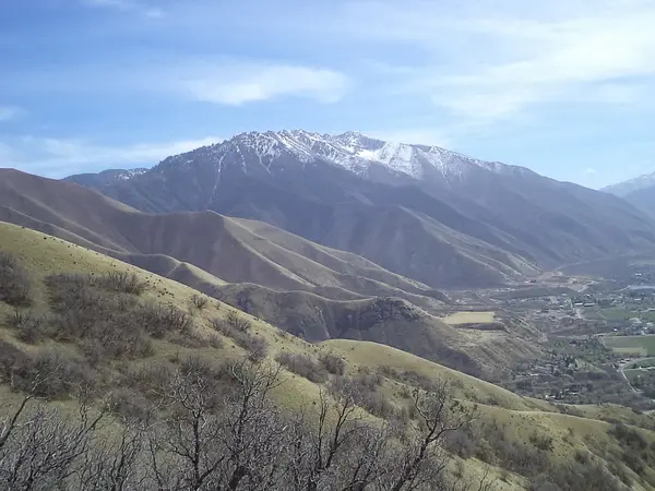
If you’ve conquered Powerhouse Mountain and are looking for the next level of Wasatch dominance, there is one peak that looms larger than the rest. Standing at 10,192 feet, Spanish Fork Peak (often called Maple Mountain by those of us in Springville) is a local rite of passage.
It is a grueling, beautiful, and absolutely relentless climb that rewards you with some of the most expansive views in the entire state.
The Stats: By the Numbers
Make no mistake—this is a "big day" hike. Unlike the shorter trails in the lower canyons, Spanish Fork Peak requires a full commitment of time and energy.
-
Elevation Gain: ~4,600 feet
-
Distance: ~10 miles round-trip
-
Time: 6 to 9 hours (depending on your pace and how long you linger at the top)
-
Difficulty: Strenuous/Expert
The Journey: From Campground to Clouds
Most hikers begin their ascent at the Whiting Campground trailhead in Mapleton. The trail (Forest Service Trail #007) is well-defined but offers very little in the way of "flat" recovery time.
The Gate Status to Whiting Campground
-
Winter/Spring Closure: There is a gate at the mouth of the canyon (where 400 North in Mapleton turns into Maple Canyon Road). This gate is closed by Mapleton City or the Forest Service once significant snow accumulates and usually remains closed through the spring melt.
-
Reopening: The road typically reopens in mid-to-late May, coinciding with the official opening of the Forest Service campground.
Winter Recreation Access
Even when the gate is closed to vehicles, the area remains a popular spot for winter activities. Many locals park at the gate and continue on foot, snowshoes, or cross-country skis.
-
Snowshoeing & Hiking: The trail from the gate through the campground and into the canyon is a favorite for a quiet winter walk.
-
Wildlife: Winter is a great time for birding in this canyon; it's common to spot Golden Eagles or the occasional Northern Pygmy Owl in the maples and cottonwoods.
1. The Forest Grind
The first few miles take you through a dense canopy of Box Elder, Douglas Fir, and Aspen. It’s shaded and beautiful, but the incline is consistent. You’ll cross several small streams—be sure to enjoy the sound of the water, as the upper reaches of the mountain are much drier.
2. Maple Canyon Lake
Around the 4-mile mark, you’ll emerge into a high alpine meadow that feels a world away from the valley floor. Here lies Maple Canyon Lake. Depending on the time of year, this "lake" can range from a shimmering pond to a dry grassy basin. It is the perfect place to refuel before the final, most difficult push.
3. The Final Ridge
From the lake, the trail turns into a series of steep switchbacks that gain the ridgeline. This is where the views truly open up. Once you hit the saddle, you can see deep into the heart of the Wasatch to the east and the sprawling urban landscape of Utah County to the west.
The Summit Experience
The summit is marked by a large rock cairn and a metal survey marker. Standing here, you are over 5,000 feet above the valley floor.
-
To the North: You’ll see the jagged peaks of Mount Timpanogos and Provo Peak.
-
To the South: Mount Nebo, the highest point in the Wasatch, dominates the horizon.
-
The Logbook: Don't forget to sign the summit register tucked away in the mailbox at the top!
Pro-Tips for a Successful Summit
-
Start at Sunrise: Afternoon thunderstorms are a real threat on high ridges in the summer. Aim to be off the summit by noon.
-
Knee Protection: The 4,600-foot descent is famously tough on the joints. Trekking poles are highly recommended for the way down.
-
Water Strategy: Bring at least 3 liters of water. While there are stream crossings in the first two miles, there is no reliable water once you leave the meadow near the lake.
-
The Name Debate: Depending on who you talk to, you’re standing on Spanish Fork Peak, Maple Mountain, or even Mount Flonette. Regardless of what you call it, the view is the same!
Ready to Bag the Peak?
Hiking to 10,000 feet is no small feat, but looking up from Springville the next morning and knowing you stood on that highest point is a feeling like no other.
Categories
Recent Posts